

Message from Sheriff Wayne Ivey
BREVARD COUNTY, FLORIDA – Even with dark clouds overhead and a storm headed straight for us, the character and humanity of Brevard County shines bright.
These photos were taken this afternoon at our Animal Care Center where people from all walks of life are lined up to foster dogs and cats during Hurricane Milton.
People have been flowing in all morning to help empty the Animal Care Center before the storm arrives and I personally think their acts of compassion are a true testament to just how special Brevard County is.
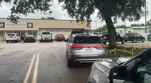
These folks have all secured their families, their homes, and their businesses, and are now helping to secure a homeless pet during the storm so they have someone to keep them calm as the impacts roll in.
A huge thank you to everyone for helping out during the storm, and of course a huge thank you to our Animal Services Team for all they do each and every day to take care of homeless pets in our community.
And finally, a big thank you to those team members who will be staying overnight at the Animal Care Center to keep watch over our pets throughout the storm.
I tell people every day how amazing this community is and how proud I am to be a part of it!! As I always say…”it takes a community to protect a community!”
– Sheriff Wayne Ivey
WATCH: Live Hurricane Milton update and information with Brevard County Sheriff Wayne Ivey and Emergency Management Director John Scott on Wednesday morning. East central Florida should prepare for hurricane force winds, especially in gusts. In addition, the Storm Surge Warning is now in effect for Brevard Barrier Islands. Surge heights up to 5 feet will be possible. The tornado threat will increase beginning Wednesday. Preparations should be complete by Wednesday morning at the latest.
WATCH: Florida Gov. Ron DeSantis Provides a Hurricane Milton Update at State Emergency Operations Center Wednesday morning at 10 a.m. East central Florida should prepare for hurricane force winds, especially in gusts. In addition, the Storm Surge Warning is now in effect for Brevard Barrier Islands. Surge heights up to 5 feet will be possible. The tornado threat will increase beginning Wednesday. Preparations should be complete by Wednesday morning at the latest.
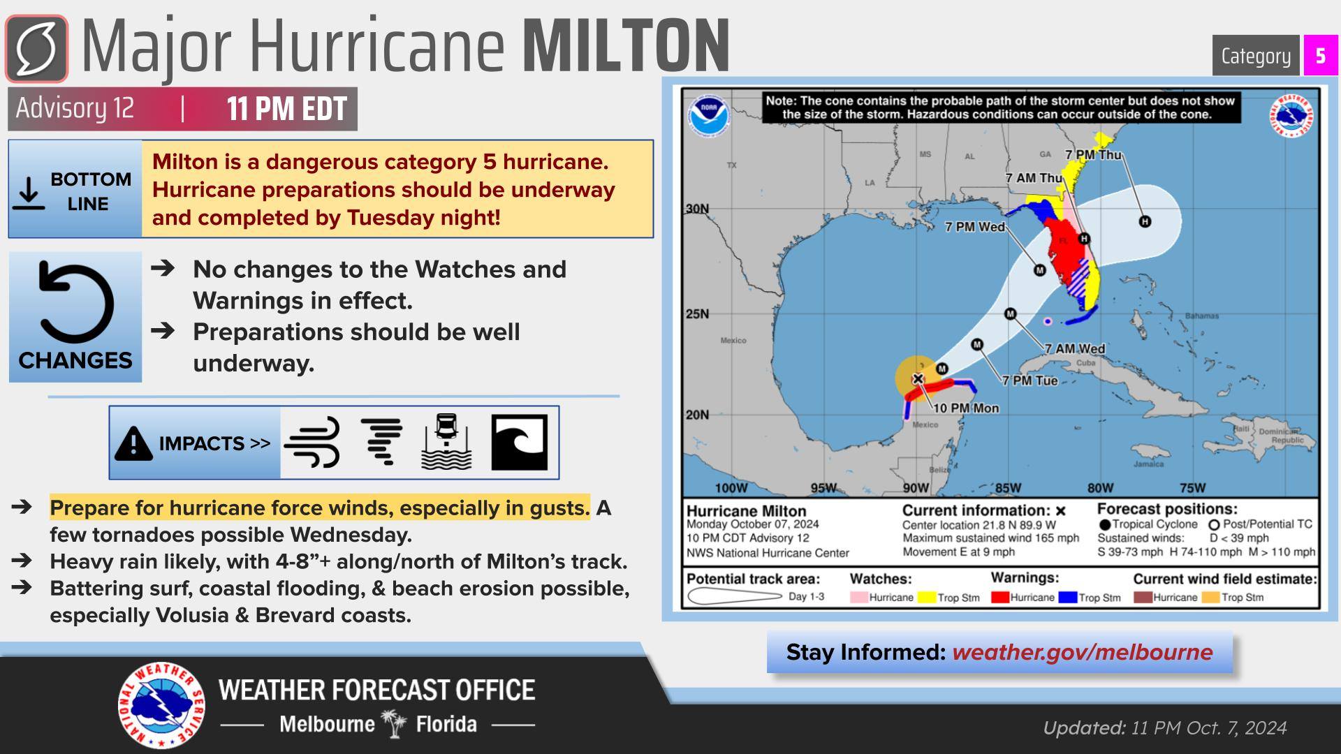
The latest forecast from the National Hurricane Center projects Brevard County could see 6 to 10 inches of rain, and sustained winds of 55 to 75 mph, with higher wind gusts of 80 mph.
BREVARD COUNTY, FLORIDA – Hurricane Milton is a very dangerous Cat 4 hurricane. The flooding rainfall threat has increased significantly along the I-4 corridor. Life-threatening street and urban flooding will be possible through Friday. Never drive through flooded roadways!
East central Florida should prepare for hurricane force winds, especially in gusts. Find more info at HERE.
In addition, the Storm Surge Warning is now in effect for Brevard Barrier Islands. Surge heights up to 5 feet will be possible. The tornado threat will increase beginning Wednesday. Preparations should be complete by Wednesday morning at the latest.
■ Wind Speed: Equivalent Cat 1 Hurricane force wind, Peak Wind Forecast of 55-75 mph with gusts to 85 mph.
■ Window for Tropical Storm force winds: Wednesday evening until Thursday evening.
■ Window for Hurricane force winds: Early Thursday morning until Thursday afternoon. Some roads impassable from large debris, and more within urban or heavily wooded places. Several bridges, causeways, and access routes impassable. Large areas with power and communications outages.
■ Storm Surge: Localized storm surge possible – Peak Storm Surge Inundation: The potential for up to 2 feet above ground somewhere within surge prone areas, Wednesday afternoon until Friday afternoon. Plan for storm surge flooding greater than 1 foot above ground. Complete preparations for storm surge flooding, especially in low-lying vulnerable areas, before conditions become unsafe.
■ Flood Watch is in effect, Peak Rainfall Amounts: Additional 4-8 inches, with locally higher amounts.
■ Situation is favorable for tornadoes, listen for tornado watches and warnings. If a tornado warning is issued, be ready to shelter quickly.
Space Coast residents should have their final preparations for Hurricane Milton made by Wednesday morning, and longtime Central Florida Meteorologist and Space Coast Daily correspondent Danny Treanor offers some sage advice and reminders on how to prepare for a storm. CLICK HERE TO WACH
WATCH: Live Hurricane Milton update and information with Sheriff Wayne Ivey and Emergency Management Director John Scott from earlier today.

The National Weather Service on Wednesday calls for Tropical storm conditions possible, with hurricane conditions also possible. Showers and possibly a thunderstorm. High near 85. Chance of precipitation is 80%.
Wednesday Night: Hurricane conditions possible. Showers and possibly a thunderstorm. Low around 76. Chance of precipitation is 90%.


:max_bytes(150000):strip_icc():focal(737x398:739x400)/arizona-desert-stock-photo-070325-5e83b6f5c0874c8fb261b0eaadc342b9.jpg "Missing 5-Year-Old Boy Found Safe in Arizona Desert After Wandering off with Dog")
